A major winter storm with snow and ice spreads across a 2,600-mile stretch of the United States.
This week, a massive winter storm stretching 2,600 miles from coast to coast across the northern U.S. will unload heavy snow over the upper Midwest while spreading an ice mix near the Iowa/Nebraska border to New England's north coast, AccuWeather meteorologists warn.
The storm will move east along an area of temperature anisotropy with record-challenging warm air to the south and cooler air to the north across southern Canada associated with the polar vortex.
Winter storm warnings were issued across the Pacific Northwest and parts of the Rocky Mountains on Monday, while winter storm watch extended from parts of Wyoming to western Wisconsin.
Significant travel disruptions are expected as the storm, with cold air, and heavy snow extends over much of the west in the middle of the week. The same storm will spread up to 2 feet of snow from South Dakota into central Minnesota and northern parts of Wisconsin and Michigan from Tuesday through Thursday. This includes the major metro area of Minneapolis and St. Paul.
"There's a good chance Minneapolis will pick up 18 inches of snow or more from the storm," AccuWeather meteorologist Matt Benz said. "February's record of 13.8 inches of snow from a single storm is likely to be broken." Additionally, the snowfall could rank among the largest on record for any month in the city's recorded history.
Forecasters say there is a possibility that Minneapolis-St. Paul International Airport will be closed for some time during the storm. Many flights will likely be delayed and canceled.
In the region, portions of several major highways in the north-central states, such as Interstates 29, 35, 90, and 94, could be closed during the storm's peak due to heavy snow.
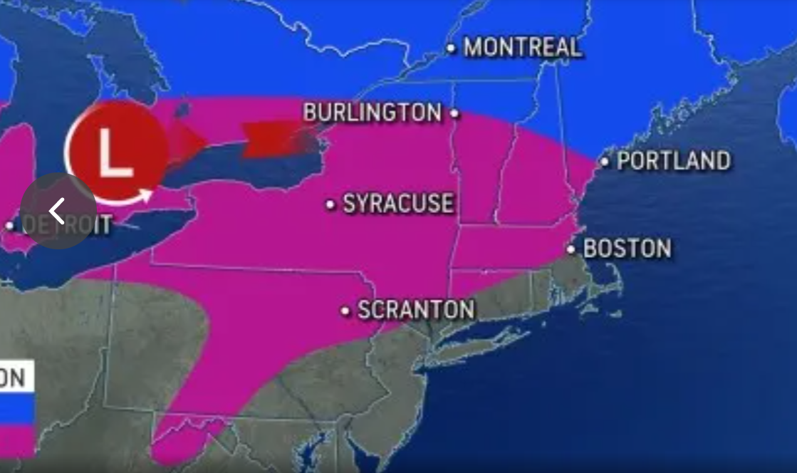
Farther south, the storm will produce an ice band roughly 1,300 miles long from near Omaha, Nebraska, to Portsmouth, New Hampshire. The icy and dangerous travel area with the potential for severe damage to trees and power lines includes Milwaukee and Detroit, as well as the northern suburbs of Chicago and Boston.
In parts of northern Illinois, the southern part of Michigan's lower peninsula, and southern New York, it is possible for an ice coating 0.25 to 0.50 inches thick to accumulate on exposed surfaces. Such a large amount of ice could lead to widespread power outages.
Airlines will likely be delayed at Chicago's O'Hare International Airport due to the need for snow removal operations. A large amount of snow may also force Metro Detroit Airport to close for some time and cause many flight delays and cancellations.
Cascading-impact airlines will likely be disrupted across the country due to the number of planes and crews likely to be displaced by the storm in Minneapolis and Detroit.
In the Northeast, areas of snow, ice, and rain are likely to spread to the north and south. In parts of northern Ohio, most of central Pennsylvania, the lower Hudson Valley in New York, and central New England, icy areas may be limited to elevated surfaces, such as bridges, trees, and vehicles.
East of the Great Lakes, heavy snow will fall over northern parts of Vermont, New Hampshire, and Maine, where 12-18 inches are expected. General snow is stored between 6 and 12 inches in most coastal Maine and northern New York.
Meanwhile, in the storm's warm sector, rain may be accompanied by thunder and lightning from the Ohio Valley to the central Appalachians and mid-Atlantic regions. Some showers over the Mississippi and Ohio valleys could become severe. Rains are in store for New York City, Philadelphia, Washington DC, and Pittsburgh from the storm and Cincinnati and St. Louis in the Midwest.
Looking ahead, additional rounds of snow and ice are likely over the upper Midwest and the northern third of the Northeast during the latter part of February through March, according to AccuWeather's team of long-range forecasters.
Post a Comment