Buffalo buried in record-setting snowfall amid a deadly lake-effect Blizzard.
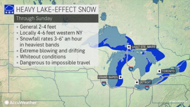
The same powerful storm that brought blizzard conditions and severe cold to a large portion of the central United States has generated a major lake-effect snow event into the Christmas weekend. Conditions have turned deadly, with three fatalities reported in the greater Buffalo area as of Saturday.
On Saturday morning, two fatalities from the storm were announced by Erie County Executive Mark Poloncarz, with both occurring in Cheektowaga, about 7 miles east of downtown Buffalo. The deaths were categorized as "emergency medical events that responders could not get to." A third death was reported Saturday afternoon, as a body was found in the city, according to a Buffalo police spokesperson. Poloncarz added that Erie County, New York, where Buffalo is located, is "preparing to encounter more fatalities" as search and rescue missions continue throughout the day.
Members of the National Guard were out in Erie County Saturday morning working on getting people out of stranded cars, targeting the hardest-hit areas, including Buffalo and the surrounding north towns.
During Friday and overnight Saturday, local first responders and emergency equipment were unable to reach hard-hit spots, including Buffalo, unable to "even go a few blocks," according to Poloncarz. "Getting first responders back online is our top priority," he said.
"In Buffalo, this storm will likely at least jump near the top of the list of worst blizzards in the city's history, if not even becoming the worst," AccuWeather Meteorologist Jake Sojda said. "Four to 6 feet of snow will fall by Sunday and coupled with wind gusts approaching hurricane force [74 mph or greater] to create enormous drifts and impossible travel."
A blizzard is defined by the National Weather Service as sustained or wind gusts to 35 mph or greater with visibility of one-quarter of a mile or less in snow or blowing snow for at least three consecutive hours.
The storm began as a rain event for Buffalo, with the city receiving 1.98 inches on Friday, breaking the prior daily record of 1.73 inches that had stood since 1878. As Arctic air rushed in, rain changed to heavy snow Friday morning. The Buffalo airport recorded zero-mile visibility for nearly 16 hours from midday Friday to the early morning hours of Christmas Eve.
"One of the most extensive, most intense blizzards I've ever covered," Extreme Meteorologist Reed Timmer said amid the snowstorm.
Reed Timmer braves the epic Blizzard and Arctic cold in Buffalo, New York, late Friday, Dec. 23, 2022.
"Just a feeling out here of helplessness not being able to see anything, losing your sense of up versus down," Timmer explained as the wind-driven snow howled around him.
Friday's total snowfall ended at a record of 22.3 inches in the city, nearly doubling up the previous daily maximum snowfall record of 12.6 inches set in 1976. A total of 28.1 inches of snow has been recorded so far at the airport as of Saturday afternoon.
A blizzard warning remains in effect for the metro area until 7 a.m. EST Sunday as an intense lake-effect band will persist Lake Erie downwind into Christmas Day. The conditions forced the closure of Buffalo Niagara International Airport until at least 11 a.m. EST Monday, per New York Gov. Kathy Hochul.
"Power outages are possible across the City of Buffalo and the Western New York region throughout the storm," Buffalo Mayor Byron W. Brown said in a press conference earlier this week. As of Saturday morning, over 30,000 customers are without power in Erie County.
During the Blizzard of '77, high winds helped to blow snow from the then-frozen Lake Erie onto the shoreline and into Buffalo from late January to early February. Mountainous drifts occurred.
In the current situation, the lake is not yet frozen over, but the open waters can fuel a tremendous amount of lake-effect snow, considering the frigid conditions in the single digits and teens F much of the time.

Post a Comment